1812 - Huish Manor Farm Map 1812 Notes
 Cottages on the Hill 1812
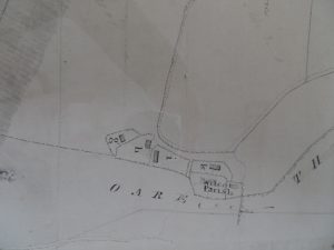
 Map of the main farm buildings by the Church with village and annotated changes noted at the bottom. Cottages and barns were removed and relocated, some on the hill. At this point there was the Pound by the pond for stray animals, or criminals. The Poor house for the village at this time was located in the field opposite the Rectory near to the wooded hollow. Barn Cottage did not exist nor did the thatched row. The smithy and carpenters yards were where Barn Cottage now sits. The Farmhouse at this time was the old thatched version set further back from the Church. This farmhouse did not burn down as some reports intimate. It was in fact demolished following a survey that reported it was no longer fit to live in and rebuilt with the permission of the Trustees in 1864. Timber from Gopher Wood was sold to pay for the new House.
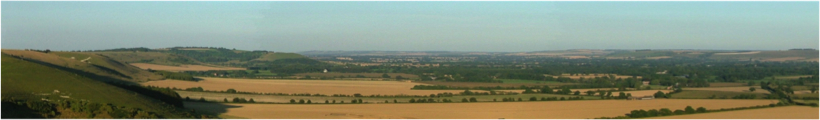
 Larger View of Village ans Farm.
Transcript of notes -Section Number
52 Late Rudman xxx given to xxx of 57
51 Betty Bradfield late Stagg
57 Tarrants [cottage] taken down and 3 new ones [cottages] built in place of the xxx wood house
10 Heath Cottages split with 6, 9, 11 Heath Ground and Parsonage Ground
5 Tarrants Ground with a pitt
1 Staggs Ground
2 Rudmans Ground
3 Matthews Ground
4 Turks Ground [ with new barn and map showing boundries between 1 and 2, 2 and 4 and 4 and 3 crossed through.
7 Heads Ground
8 Heads Ground [ All north of the Drove]
14 Great Ground
12 Long Half
17 Barn removed to 4 Turks on the Hill
16 Long Ground
18 Fowlers Acres
19 The Down
Cottages on the Hill shown as g,h,I,k
38 Picked Field
21 Bushes
20 Coppice[Gopher]
22 Smokeham
23 West Hill
24/25 Narrow strips below Gopher
26 North Field
46 Field around Church
45 Field around barns on west of Farmyard
47 Farm yard and House
48 Field opposite the Pond
49 By pond and Pound called Butter Mead
53 Taken Down
57 Barn removed to the Hill at 4 and 17 in the Hill
58 a NEW cottage and garden in the position of No 5 now [I presume the other cottages in the row numbers 1 to 4 followed].
55 Forge and Carpenters Cottage [Note Barn cottage does not exist on this map]
C denotes Parsonage or Church properties also a,b,c etc [note more buildings in this section]
51 straddled into 52 and was further south and east than the current cottages [Porch Cottage]
52 is Giddings Cottage as it is now
53 Late Matthews Cottage and garden [bottom of the hollow by the Chestnut Tree] Cottage taken down and let to Mr Faulkner now Bleek
51 Charles Staggs Cottage, outhouse and Garden
See Notes of 1841 Map for comparison and notes on the very many changes to the village and surrounds.
[2037/137H] By kind permission of Wiltshire and Swindon Family History Centre.